The province's goal is to create a resting place along the new bicycle path, so that this quality can be re-established; a resting place which focuses on the perception of the identity of the region. The identity of the region as a former shore area and dyke of the Zuyder Sea, as an important bird pasture habitat and as a place of business for skippers, fishermen and traders with the historical towns of Zwartsluis and Vollenhove as focal points. In the meanwhile the design is ready and construction is nearing. This project involved a close alliance with Heleen Bosma, Poet of Overijssel 2013 / 2014, and in liaison with and supported by parties involved. Aside from the province of Overijssel, these parties included the Water Board of Reest en Wieden, the Municipalities of Steenwijkerland and Zwartewaterland, and Natuurmonumenten (the Dutch Society for the Preservation of Nature). MTD was responsible for the design, the supervision of the communications process, the implementation preparation, and will soon supervise the construction. For the location for the resting place, which has in the meanwhile been christened
Zuiderzeezicht
, the choice was made for a spot near the Tolhuis (toll station). Here, in an outer bend of the former Zuyder Sea dyke, the water from the outer lands and the Zwartemeer is close by and can be well perceived, and there's also a view of Bird Island and the North East polder. The resting place is recognisable from the N331 roadway and the slow traffic route next to the N331 as a narrow stony staircase in the dyke embankment. The narrow staircase in the dyke embankment has an iconographic significance. The resting place is actually visible on top of the dyke with the letters ‘
Zuiderzeezicht
’ carved in the natural stone.
When climbing the stairs, the words depicted on them announces the memories of the view of the former Zuyder Sea; from the bottom to the top of the stairs the stones have been carved to read:
KIJK – BIJ ELKE TREDE DAALT HET LAND EN STIJGT HET LICHT
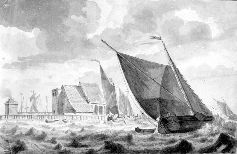
[LOOK - AT EACH STEP THE LAND DROPS AND THE LIGHT BRIGHTENS]. At the top of the dyke itself, the drama of the grand panoramic view unfolds; a view of the outer lands and the expanse of reeds, the former Zuyder Sea and the present IJsselmeer, the Bird Island and the North East polder. Then there's a place to sit, which is shaped as if the the thick stone slabs have been folded over. When one sits on this bench, two carved historical pictures are revealed in the natural stone; they depict the tumultuous history of the development of the region and the battle with the sea. On the left, a sea view dating back to 1729 is depicted with a view of the church of Ens at Schokland as seen from the still rugged Zuyder Sea, and the picture on the right shows a later sea view from 1932 by Johan Hendrik van Mastenbroek with a picture of the closing of the (polder)dyke. This enhances the proximity of the water, but the intense history of the region in relation to the Sea is also perceptible. Improvements are strengthened by the overhang of the resting place and the stone slabs over the crest of the dyke.
In order not to put any constraints on the management of the outer lands and to leave the ecological values intact as much as possible, the structure here will remain detached from the surface level. The materialisation and detailing of
Zuiderzeezicht
is timeless, robust and pure, and makes reference to the shipping and other engineering structures along the coast.